Fednav/Drones/english
观看次数1,555
视频说明
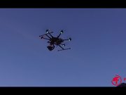
In an industry breakthrough, Fednav this month became the first shipping company to employ drones, or Unmanned Air Vehicles (UAV), for ice reconnaissance on a commercial voyage.
The Umiak I used these drones to scout ahead of the vessel in the ice-covered waters of the Labrador Coast.
The goal was to provide the captain and officers with detailed real-time visual information on the local ice conditions.
Enfotec, a Fednav subsidiary and industry leader, has specialized in providing advanced ice imagery and analysis to vessels operating in difficult ice conditions for 20 years. Despite recent advances in the quality of ice information available from satellite and radar images and conventional ice charts, there is a need to improve the information available to mariners.
The UAVs will bridge this gap by delivering critical high-quality, short-range visual observations that allow navigators to see beyond the normal horizon for navigation in ice. Identifying subtle features not visible in conventional imagery, pressure ridges and small open-water leads for example, will allow mariners to make better informed strategic navigation decisions.
The backdrop for the application of this emerging technology was the Labrador Coast, which experiences winter conditions similar to the Canadian Arctic—thick first-year ice that is heavily deformed under pressure as well as remnants of multi-year and glacial ice embedded in the ice cover—which pose great challenges for navigation. The use of UAVs is proving to be highly useful to identify such ice features that should be avoided, adding another safety measure for modern navigation in ice.
分类:
热门免费线上视频标签技术类
插件
27 四月 2017
评论